Milpitas (Milpitas)
 |
Milpitas was first inhabited by Tamien people, a subgroup of the Ohlone people who had resided in the San Francisco Bay Area for thousands of years. The Ohlone Indians lived a traditional life based on everyday hunting and gathering. Some of the Ohlone lived in various villages within what is now Milpitas, including sites underneath what are now the Calvary Assembly of God Church and Higuera Adobe Park. Archaeological evidence gathered from Ohlone graves at the Elmwood Correctional Facility in 1993 revealed a rich trade with other tribes from Sacramento to Monterey.
During the Spanish expeditions of the late 18th century, several missions were founded in the San Francisco Bay Area. During the mission period, Milpitas served as a crossroads between Mission San José de Guadalupe in present-day Fremont and Mission Santa Clara de Asis in present-day Santa Clara. The land of modern-day Milpitas was divided between the 6353 acre Rancho Rincon de Los Esteros (Spanish for "corner of the wetlands") granted to Ignacio Alviso; the 4457.8 acre Rancho Milpitas (Spanish for "little corn fields") granted to José María Alviso; and the 4394.35 acre Rancho Los Tularcitos (Spanish for "little tule marshes") granted to José Higuera. Jose Maria Alviso was the son of Francisco Xavier Alviso and Maria Bojorquez, both of whom arrived in San Francisco as children with the de Anza Expedition. José María Alviso is considered to be the founder of Milpitas. Due to Jose Maria Alviso's descendants' difficulty securing his claims to the Rancho Milpitas property, portions of his land were either swindled from the Alviso family or were sold to American settlers to pay for legal fees.
Both landowners had built prominent adobe homes on their properties. Today, both adobes still exist and are the oldest structures in Milpitas. The seriously eroded walls of the Jose Higuera Adobe, now in Higuera Adobe Park, are encapsulated in a brick shell built c. 1970 by Marian Weller, a descendant of pioneer Joseph Weller.
The Alviso Adobe can be seen mostly in its original form, with one kitchen addition made by the Cuciz family after they purchased the adobe from the Gleason family in 1922. Prior to the city acquiring the Alviso Adobe in 1995, it was the oldest continuously occupied adobe house in California dating from the Mexican period and today is still gradually being restored and undergoing seismic upgrades by the City of Milpitas.
In the 1850s, large numbers of Americans of English, German, and Irish descent arrived to farm the fertile lands of Milpitas. The Burnett, Rose, Dempsey, Jacklin, Trimble, Ayer, Parks, Wool, Weller, Minnis, and Evans families are among the early settlers of Milpitas. (Today many schools, streets, and parks have been named in honor of these families.) These early settlers farmed the land that was once the ranchos. Some set up businesses on what was then called Mission Road (now called Main Street) between Calaveras Road (now called Carlo Street) and the Alviso-Milpitas Road (now called Serra Way). By the late 20th century this area became known as the "Midtown" district. Yet another influx of immigration came in the 1870s and 1880s as Portuguese sharecroppers from the Azores came to farm the Milpitas hillsides. Many of the Azoreans had such locally well-known surnames as Coelho, Covo, Mattos, Nunes, Spangler, Serpa, and Silva.
There is a local legend that in 1857, when the U.S. Postal Service wanted to locate a Post Office in Frederick Creighton's store near the intersection of Mission Road and Alviso-Milpitas Road to serve the newly created Township, there was some support for naming it Penitencia, after the small Roman Catholic confessional building that had served local Indians and ranchers and had once stood several miles south of the village near Penitencia Creek which ran just west of the Mission Road. A local farmer and first Assistant Postmaster, Joseph Weller, felt the Spanish word Penitencia might be confused with the English word "penitentiary." Instead of choosing Penitencia, he suggested another popular name for the area, Milpitas, after the name of Alviso's property, Rancho Milpitas. Thus was born "Milpitas Township."
For over a century, Milpitas served as a popular rest stop for travelers on the old Oakland−San Jose Highway. At the north side of the intersection of that road with the Milpitas-Alviso Road, for many years stood "French's Hotel" that had been originally built by Alex Anderson prior to 1859, when Alfred French bought it from Austin M. Thompson. South of the site of French's Hotel, was a saloon dating from at least 1856 when Agustus Rathbone purchased the land and "improvements" from Richard Greenham. The first murder in Milpitas was committed in the early 1860s in "Rathbone's Saloon" (alas, the murderer escaped). Later the saloon was replaced by a hotel that is shown on the 1893 Sanborn Fire Insurance Map as "Goodwin's Hotel" (perhaps the same Henry K. Goodwin who, in 1890, loaned money to prominent local rancher Marshall Pomeroy). Presumably, this hotel burned down and "Smith's Corner," which still stands, was built in 1895, by John Smith, as a saloon that served beer and wine to thirsty travelers for a century before becoming a restaurant in 2001. Around this central core, grocery and dry goods stores, blacksmithies, service stations, and, in the 1920s, one of America's earliest "fast food" chain restaurants, "The Fat Boy", opened nearby. Another of Milpitas's most popular restaurants was the "Kozy Kitchen", established in 1940 by the Carlo family in the former "Central Market" building. Kozy Kitchen was demolished soon after Jimmy Carlo sold the restaurant in 1999. Even in the early 1950s, Milpitas served a farming community of 800 people who walked a mere one or two blocks to work.
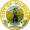
On January 26, 1954, faced with getting swallowed up by a rapidly expanding San Jose, Milpitas residents incorporated as a city that included the recently built Ford Auto Assembly plant. When San Jose attempted to annex Milpitas barely seven years later, the "Milpitas Minutemen" were quickly organized to oppose annexation and keep Milpitas independent. An overwhelming majority of Milpitas registered voters voted "No" to annexation in the 1961 election as a result of a vigorous anti-annexation campaign. Following the election, the anti-annexation committee, who had compared themselves to the Revolutionary War Minutemen who fought the British on Lexington Green—a role filled in this case by the neighboring city of San Jose—adopted the image of Daniel Chester French's Minuteman statue, that stands near the site of the Old North Bridge in Concord, MA, as part of the official city seal. In the 1960s, the city approved the construction of the Calaveras overpass. Formerly at a junction with the Union Pacific railroad, Calaveras Boulevard had a bridge passing over six sets of railroad tracks after the construction was completed. Though the result was that local residents could now drive over the train tracks without waiting for a slow freight to pass, it resulted in the loss of the historical residential area. Here houses owned by city leaders had to be purchased by the city at full market value and either moved or demolished.
Starting in 1955, with the construction of the Ford Motor Assembly Plant, and accelerating in the 1960s and 1970s, extensive residential and retail development took place. Hayfields in Milpitas rapidly disappeared as industries and residential housing developments spread. Soon, the once rural town of Milpitas found itself a San Jose suburb. The population jumped from about 800 in 1950 to 62,698 in 2000. Several local farmers and businessmen who had chipped in from $2 to $50 to file for incorporation, had become millionaires within ten years. Most of them then moved away.
Map - Milpitas (Milpitas)
Map


Country - United_States
 |
 |
| Flag of the United States | |
Indigenous peoples have inhabited the Americas for thousands of years. Beginning in 1607, British colonization led to the establishment of the Thirteen Colonies in what is now the Eastern United States. They quarreled with the British Crown over taxation and political representation, leading to the American Revolution and proceeding Revolutionary War. The United States declared independence on July 4, 1776, becoming the first nation-state founded on Enlightenment principles of unalienable natural rights, consent of the governed, and liberal democracy. The country began expanding across North America, spanning the continent by 1848. Sectional division surrounding slavery in the Southern United States led to the secession of the Confederate States of America, which fought the remaining states of the Union during the American Civil War (1861–1865). With the Union's victory and preservation, slavery was abolished nationally by the Thirteenth Amendment.
Currency / Language
| ISO | Currency | Symbol | Significant figures |
|---|---|---|---|
| USD | United States dollar | $ | 2 |
| ISO | Language |
|---|---|
| EN | English language |
| FR | French language |
| ES | Spanish language |